Welcome to a place where you can explore the administrative history of the Holy Roman Empire (HRE) and find an accurate and complete place name to put into your genealogy program for your ancestors’ places of birth, marriage, and death in what is now Germany.
I see a Search bar. What do I search for?
If you know the village or city where your ancestor’s event took place, type it into the Search bar and click on the name most similar to the one you want. When you get to the results page, enter the year of the event. You will then see a complete place name for that village/city in the selected year, which you can copy directly into your genealogy program. Below that, you will see the same results presented so that you can match the different levels to their full names. The Glossary link at the bottom will tell you what those levels mean. If you click on “See all time periods”, you can see the same presentation for the entire period between roughly 1600 and 1806.
Can I search for any village or city in the Holy Roman Empire?
Not yet. Check the list below for regions that are ready for searching. Click on the “Where it this?” link to find out where the region is. If you click on the region name itself, you can see two lists:
- All the countries in that region between roughly 1600 and 1806. (Note that a country the size of Belgium was considered pretty big back then.)
- All of the country subdivisions in that region during the same time period. (These tended to move around, so I didn’t try to associate them with a single country.)
Once you get into the Region pages, there is all sorts of exploring you can do. Have at it. Anyway, here is the list of supported regions by month added:
- September, 2023 (918 places)
- Anhalt (Where is this?)
- Halberstadt (Where is this? Just west of Anhalt)
- Lippe (Where is this?)
- Schaumburg (Where is this?)
- October, 2023 (212 places)
- November, 2023 (355 places)
- January, 2024 (669 places)
- February, 2024 (508 places)
- April, 2024 (903 places)
- May, 2024 (361 places)
- July, 2024 (253 places)
- Hamburg/Harburg (Where is this?)
- Bremen (Imperial City only) (Where is this?)
- September, 2024 (543 places)
- October, 2024 (316 places)
- March, 2025 (728 places)
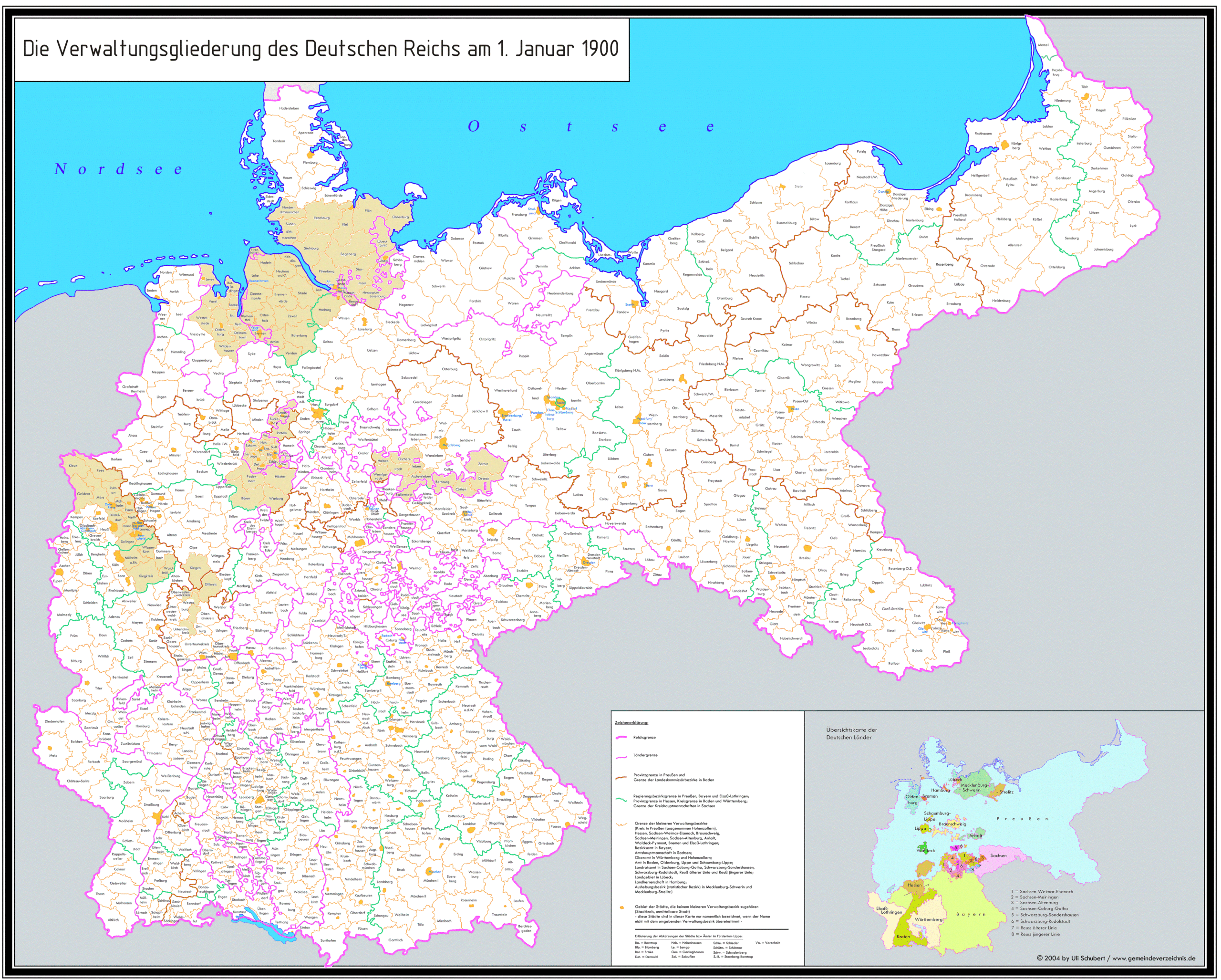
You can check on my progress visually on this coverage map. Areas that have been added to the database are shaded tan. The base map represents the administrative structure of the German Empire in 1900. The boundaries on that map conform much more closely to those of HRE entities than would those on a map of the current administrative boundaries. That conformity allows me to generate a more accurate (but still imperfect) coverage map. The original base map (found here) is the property of Uli Schubert and I gratefully use it with his permission.
When can I expect to see the region I am most interested in?
To put it bluntly, you can expect to see it when you pay to see it. That’s not to say it won’t eventually show up anyway. But because I am not charging any fees to use this site, my incentive to add new regions is limited to my own interest. I fully intend to keep adding regions as my time and interest permits. But if there is a region you think I should give higher priority to, I am open to that, given sufficient incentive.
How confident should I be in these results?
If you’re an amateur genealogist, I would say you can be pretty confident. That said, errors undoubtedly have snuck in and some of my results are going to be controversial in any case. Therefore, I have to add the caveat that my results should not be relied on for any purpose that involves making money–directly or indirectly. Specifically, this website should not be used for the following purposes:
- Academic citations. In each Region page I link to above, I have included a link to a Sources page. All academic citations should reference those sources, not this website. Nonacademic users may copy my lists and text as long as they are attributed to this website and are not offered for sale or placed behind any kind of paywall.
- Legal evidence. Nothing on this website should be considered reliable as evidence in any legal matter to which I am not a party. No exceptions.
Paul Burnham